cancel
Showing results for 
Search instead for 
Did you mean: 

July 28 - August 9 | Final Round of the Power BI Dataviz World Championships. This is your chance. Learn more

Reply
Anonymous
Not applicable

Multipoint GeoJson data to map

Hi,


I'm new to Power Bi and I would like to achieve a map with multipoints from a geoJson data.


Here is an example geoJson data with 2 points (coordinates)


{
"type": "FeatureCollection",
"features": [
{
"type": "Feature",
"geometry": {
"type": "MultiPoint",
"coordinates": [
[
4.446657,
51.02457
],
[
4.479846,
50.944796
]
]
},
"properties": {
"prop0": "value0"
}
}
]
}

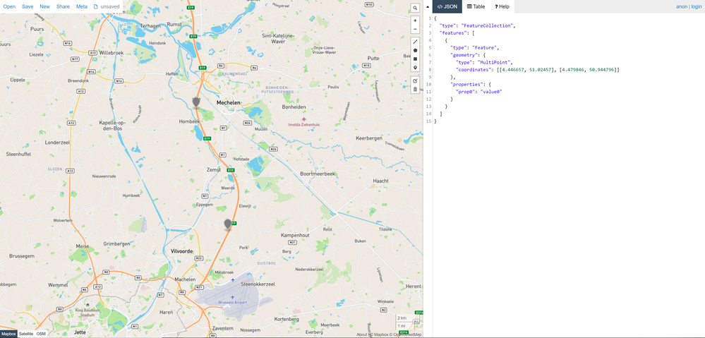
And here is an example what I would like to achieve.

2020-07-31_10-19-34.png


I couldn't find much information on web how I can use Power Bi with geoJson data. Is that possible to achieve multipoint map with Power Bi? How can i do that? Thanx

1 ACCEPTED SOLUTION
Anonymous
Not applicable

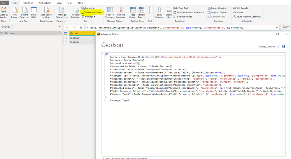
Step 1. Save your geojson in Json format : GeoJson.Json

Step 2. Paste below advanced query in the advanced editor in transform data :
 let
Source = Json.Document(File.Contents("C:\Users\Desktop\geojson.json")),
features = Source[features],
features1 = features{0},
#"Converted to Table" = Record.ToTable(features1),
#"Transposed Table" = Table.Transpose(#"Converted to Table"),
#"Promoted Headers" = Table.PromoteHeaders(#"Transposed Table", [PromoteAllScalars=true]),
#"Changed Type" = Table.TransformColumnTypes(#"Promoted Headers",{{"type", type text}, {"geometry", type any}, {"properties", type any}}),
#"Expanded geometry" = Table.ExpandRecordColumn(#"Changed Type", "geometry", {"type", "coordinates"}, {"type.1", "coordinates"}),
#"Expanded properties" = Table.ExpandRecordColumn(#"Expanded geometry", "properties", {"prop0"}, {"prop0"}),
#"Expanded coordinates" = Table.ExpandListColumn(#"Expanded properties", "coordinates"),
#"Extracted Values" = Table.TransformColumns(#"Expanded coordinates", {"coordinates", each Text.Combine(List.Transform(_, Text.From), ","), type text}),
#"Split Column by Delimiter" = Table.SplitColumn(#"Extracted Values", "coordinates", Splitter.SplitTextByDelimiter(",", QuoteStyle.Csv), {"coordinates.1", "coordinates.2"}),
#"Changed Type1" = Table.TransformColumnTypes(#"Split Column by Delimiter",{{"coordinates.1", type number}, {"coordinates.2", type number}})
in
#"Changed Type1"

Step 3: Close and Apply 

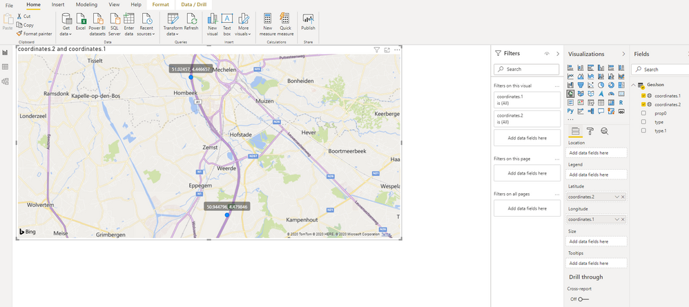
step 4: Change the data type of cordinates.1 and cordinates.2 by selecting the columns to logitude and latitude respectively.
step 5 : pull the logitude and latitude in map visual.Final.PNGTransformdata-->Getdata-->Newquery-->advancededitor--> cody the code and paste--> applyTransformdata-->Getdata-->Newquery-->advancededitor--> cody the code and paste--> apply
View solution in original post

1 REPLY 1
Anonymous
Not applicable

Step 1. Save your geojson in Json format : GeoJson.Json

Step 2. Paste below advanced query in the advanced editor in transform data :
 let
Source = Json.Document(File.Contents("C:\Users\Desktop\geojson.json")),
features = Source[features],
features1 = features{0},
#"Converted to Table" = Record.ToTable(features1),
#"Transposed Table" = Table.Transpose(#"Converted to Table"),
#"Promoted Headers" = Table.PromoteHeaders(#"Transposed Table", [PromoteAllScalars=true]),
#"Changed Type" = Table.TransformColumnTypes(#"Promoted Headers",{{"type", type text}, {"geometry", type any}, {"properties", type any}}),
#"Expanded geometry" = Table.ExpandRecordColumn(#"Changed Type", "geometry", {"type", "coordinates"}, {"type.1", "coordinates"}),
#"Expanded properties" = Table.ExpandRecordColumn(#"Expanded geometry", "properties", {"prop0"}, {"prop0"}),
#"Expanded coordinates" = Table.ExpandListColumn(#"Expanded properties", "coordinates"),
#"Extracted Values" = Table.TransformColumns(#"Expanded coordinates", {"coordinates", each Text.Combine(List.Transform(_, Text.From), ","), type text}),
#"Split Column by Delimiter" = Table.SplitColumn(#"Extracted Values", "coordinates", Splitter.SplitTextByDelimiter(",", QuoteStyle.Csv), {"coordinates.1", "coordinates.2"}),
#"Changed Type1" = Table.TransformColumnTypes(#"Split Column by Delimiter",{{"coordinates.1", type number}, {"coordinates.2", type number}})
in
#"Changed Type1"

Step 3: Close and Apply 

step 4: Change the data type of cordinates.1 and cordinates.2 by selecting the columns to logitude and latitude respectively.
step 5 : pull the logitude and latitude in map visual.Final.PNGTransformdata-->Getdata-->Newquery-->advancededitor--> cody the code and paste--> applyTransformdata-->Getdata-->Newquery-->advancededitor--> cody the code and paste--> apply
Helpful resources

Announcements
Fabric Community Sticker Design Challenge Barcelona Carousel

Fabric Community Sticker Challenge - Barcelona 2026

If you love stickers, then you will definitely want to check out our community sticker challenge, Barcelona edition!

July Power BI Update Carousel

Power BI Monthly Update - July 2026

Check out the July 2026 Power BI update to learn about new features.

Power BI DataViz World Championships carousel

Power BI DataViz World Championships - June 2026

A new Power BI DataViz World Championship is coming this June! Don't miss out on submitting your entry.