Get Fabric or SQL Certified for Free.
Get certified for free when you join Fabric Data Days 2026 and dive into Fabric, Power BI, SQL, AI, and other essential data skills.
Join now- Power BI forums
- Get Help with Power BI
- Desktop
- Service
- Report Server
- Power Query
- Mobile Apps
- Developer
- DAX Commands and Tips
- Custom Visuals Development Discussion
- Health and Life Sciences
- Power BI Spanish forums
- Translated Spanish Desktop
- Training and Consulting
- Instructor Led Training
- Dashboard in a Day for Women, by Women
- Galleries
- Data Stories Gallery
- Themes Gallery
- Contests Gallery
- QuickViz Gallery
- Quick Measures Gallery
- Visual Calculations Gallery
- Notebook Gallery
- Translytical Task Flow Gallery
- TMDL Gallery
- R Script Showcase
- Webinars and Video Gallery
- Ideas
- Custom Visuals Ideas (read-only)
- Issues
- Issues
- Events
- Upcoming Events
July 7 - July 17 | Round 2 of the Power BI Dataviz World Championships. Don't miss your chance! Learn more
- Power BI forums
- Forums
- Get Help with Power BI
- Desktop
- Re: Problem using custom shape map
- Subscribe to RSS Feed
- Mark Topic as New
- Mark Topic as Read
- Float this Topic for Current User
- Bookmark
- Subscribe
- Printer Friendly Page


- Mark as New
- Bookmark
- Subscribe
- Mute
- Subscribe to RSS Feed
- Permalink
- Report Inappropriate Content
Problem using custom shape map
Converted shapefile (projection "transverse_mercator") to a Topo JSON file using the website http://mapshaper.org/ but the resulting JSON file has display problems. Here's a screenshot: (1) The left image displays the shapefile in ArcGIS. (2) The top & bottom right are the JSON maps displayed within PBI using different projections.
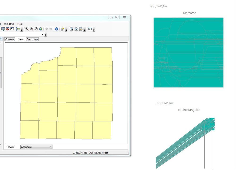
I've even "simplified" the edges of the original shapefile to reduce the number of verticies before converting to JSON.
FYI - The location attributes (from an excel file) are correctly applying to the different areas within PBI.
Any ideas of what I should do? Thank you.
Power BI version: 2.37.4464.361 64-bit (July, 2016)
Windows version: Windows 7 Pro 64-bit (SP1)
Solved! Go to Solution.


- Mark as New
- Bookmark
- Subscribe
- Mute
- Subscribe to RSS Feed
- Permalink
- Report Inappropriate Content
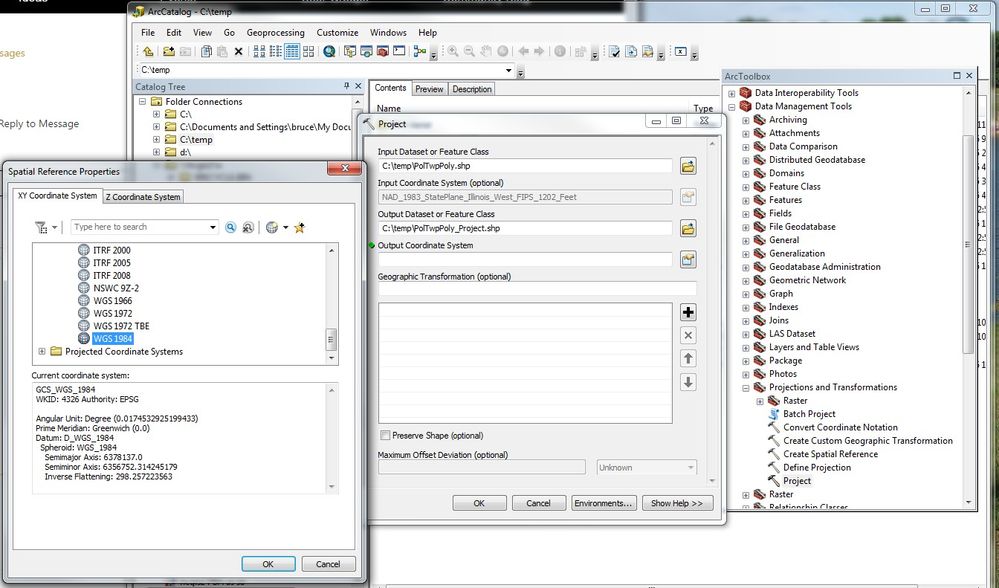
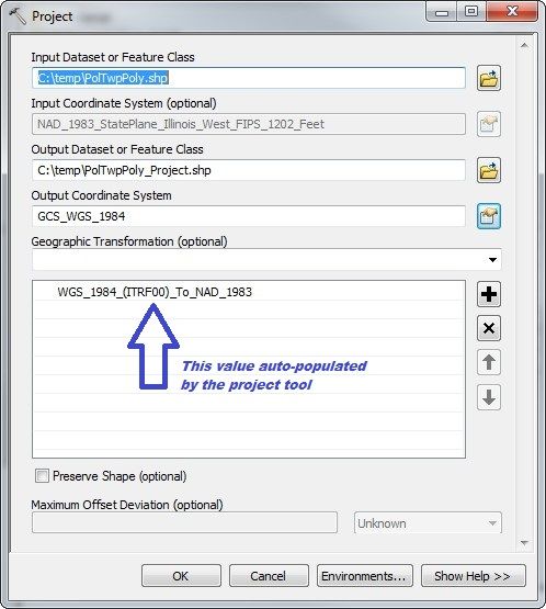
I believe that when I converted your file, I lined it up with WGS 84 / EPSG 4326 -- geographic.
- Mark as New
- Bookmark
- Subscribe
- Mute
- Subscribe to RSS Feed
- Permalink
- Report Inappropriate Content
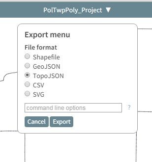
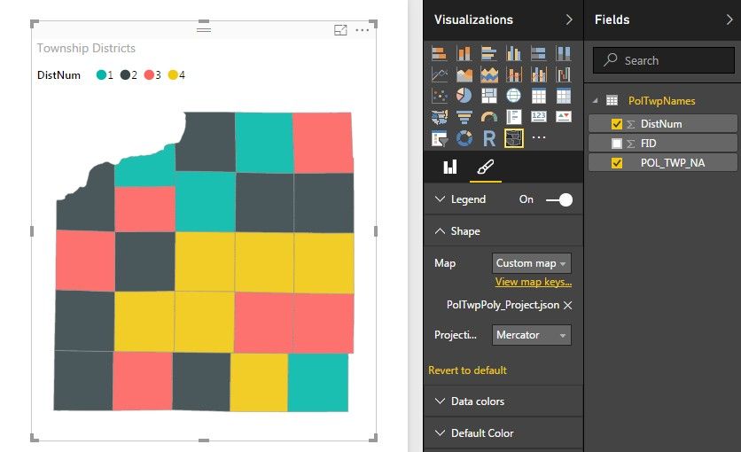
@deldersveld Thank you so much, that works great!! Here's are screen captures of the process.



- Mark as New
- Bookmark
- Subscribe
- Mute
- Subscribe to RSS Feed
- Permalink
- Report Inappropriate Content
Hi, I'm having this issue with shape maps in powerbi so I think your writeup on the solution might be exactly what I need (I know almost nothing about ArcGIS!) but when I follow the link I get, "
Private Site
This site is currently private. Log in to WordPress.com to request access."

I don't have a WordPress login so I wondered if there's any other way I could access this please?

- Mark as New
- Bookmark
- Subscribe
- Mute
- Subscribe to RSS Feed
- Permalink
- Report Inappropriate Content
I have tried for weeks to convert to the correct projection, but it does not work... could someone convert this shape to topojson please? I have tried with QGIS, ARCMAP, used http://mapshaper.org/ but it continues showing in powerbi the Picaso Effect, The link of the shape is this : https://drive.google.com/file/d/1kbY_HkCulQzWD8SgJkP9nHu9bjmILY3U/view?usp=sharing

- Mark as New
- Bookmark
- Subscribe
- Mute
- Subscribe to RSS Feed
- Permalink
- Report Inappropriate Content
Can you help me
i want to use some countries shape maps that are not in Power BI, for example Finland, i downloaded the GeoJSON file from here
http://code.highcharts.com/mapdata/
Finland http://code.highcharts.com/mapdata/countries/fi/fi-all.geo.json
Then I opened in http://mapshaper.org/ and exported as TopoJSON
When i open it in Power IB I can not see the map onliy lines as previous user
Can you help me?

- Mark as New
- Bookmark
- Subscribe
- Mute
- Subscribe to RSS Feed
- Permalink
- Report Inappropriate Content
Hi!
The GeoJson you had behind the link has things throwing PowerBI off,
- it has Scandinavian chars (e.g. ä = ä "Itä-Uudenmaan maakunta") - reading this evening through several stack traces when trying to feed multipolygon GeoJson for PowerBI, it just rolls down and cries if it sees something outside Latin1. meh.
- according to validation feedback from GeoJsonLINT the GeoJson you have there also does not follow the right hand rule, which seems to be a thing also.
Having run around internjets for a moment now seeking for a suitable source, I am not seeing a clean WGS-84 compliant, right-hand rule -following GeoJson of Finnish borders, let alone one with e.g. postalcode area geographies. I will do something about it (create one, validate it, test it with PowerBI) tomorrow and be back. In case I succeed and you are still struggling with this, ping me at
- Mark as New
- Bookmark
- Subscribe
- Mute
- Subscribe to RSS Feed
- Permalink
- Report Inappropriate Content
Can you help me
i want to use some countries shape maps that are not in Power BI, for example Finland, i downloaded the GeoJSON file from here
http://code.highcharts.com/mapdata/
Finland http://code.highcharts.com/mapdata/countries/fi/fi-all.geo.json
Then I opened in http://mapshaper.org/ and exported as TopoJSON
When i open it in Power IB I can not see the map onliy lines as previous user
Can you help me?

Helpful resources

FabCon & SQLCon – Barcelona 2026
Join us in Barcelona for FabCon and SQLCon, the Fabric, Power BI, SQL, and AI community event. Save €200 with code FABCMTY200.

Data Days 2026
Join Fabric Data Days 2026: 60 days of free live/on-demand sessions, challenges, study groups, and certification opportunities.

Power BI DataViz World Championships - June 2026
A new Power BI DataViz World Championship is coming this June! Don't miss out on submitting your entry.

| User | Count |
|---|---|
| 24 | |
| 24 | |
| 17 | |
| 14 | |
| 13 |


| User | Count |
|---|---|
| 64 | |
| 41 | |
| 39 | |
| 39 | |
| 38 |


