Forum Discussion

ArcGIS wrong location using Parishes id
Hi,
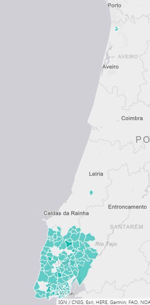
I'm trying to represent location as Boundaries selecting "Portugal" as country in the arcgis options. I'm using Parishes id's as Location type. I found a lot of issues.. examples of id's:
111609
111415
110921
110919
(....) a lot
any solution? because, if I use parishes names, the map can't find a lot of them correctly.
7 Replies
- AnonymousNot applicable
Hi,
I'm trying to represent location as Boundaries selecting "Portugal" as country in the arcgis options. I'm using Parishes id's as Location type. I found a lot of issues.. examples of id's:
111609
111415
110921
110919
(....) a lot
any solution? because, if I use parishes names, the map can't find a lot of them correctly.
 Eric_Zhang
Microsoft Employee
Anonymous
Could you please upload the pbix to help test? You can save it in a network drive like Onedrive and share the link.
By the way, ArcGIS is provided by esri, you could try to contact it for straightforward support.
- AnonymousNot applicable
Hi Eric_Zhang,
A sample: goo.gl/QrK0DJ
If you choose "Lisboa" you will see that some parishes are wrong. Is better open a ticket in esri support?
- Eric_Zhang
Anonymous wrote:
Hi Eric_Zhang,
A sample: goo.gl/QrK0DJ
If you choose "Lisboa" you will see that some parishes are wrong. Is better open a ticket in esri support?
I don't have access to this sample.
- AnonymousNot applicable
Eric_Zhang, as Scott Ball said in this article ( https://blogs.esri.com/esri/arcgis/2016/10/11/5-common-questions-about-arcgis-maps-for-power-bi/ ),
- "We have some ‘fuzzy search’ capabilities that give some flexibility that allows our backend to provide results even when a user doesn’t match the location name we have exactly. This is especially useful when the place name has diacritical marks but the user dataset does not contain diacriticals – it allows users to get results without exact matches."
- "Fuzzy search is a problem, however, whenever you have exact ID’s such as ZIP or postal codes. 92373 is very close to 92374, but you would never want to return the geometry info for 92374 if you want to map 92373. Our fix looks at the data model, and if the user has marked a data field in Power BI as a ‘Postal Code’ field, we turn off fuzzy search when that field is mapped. Only exact matches will be returned. It will involve a little extra effort on your part, but the results will be much better."
I suppose this is the problem I'm facing with my parishes id's. He said that "the patch was delivered along with a slew of other bug fixes and enhancements to Microsoft this weekend and should be rolling out in the coming weeks"
I will wait this patch to see if the problem is gone.
- Eric_Zhang
Anonymous wrote:
Eric_Zhang, as Scott Ball said in this article ( https://blogs.esri.com/esri/arcgis/2016/10/11/5-common-questions-about-arcgis-maps-for-power-bi/ ),
- "We have some ‘fuzzy search’ capabilities that give some flexibility that allows our backend to provide results even when a user doesn’t match the location name we have exactly. This is especially useful when the place name has diacritical marks but the user dataset does not contain diacriticals – it allows users to get results without exact matches."
- "Fuzzy search is a problem, however, whenever you have exact ID’s such as ZIP or postal codes. 92373 is very close to 92374, but you would never want to return the geometry info for 92374 if you want to map 92373. Our fix looks at the data model, and if the user has marked a data field in Power BI as a ‘Postal Code’ field, we turn off fuzzy search when that field is mapped. Only exact matches will be returned. It will involve a little extra effort on your part, but the results will be much better."
I suppose this is the problem I'm facing with my parishes id's. He said that "the patch was delivered along with a slew of other bug fixes and enhancements to Microsoft this weekend and should be rolling out in the coming weeks"
I will wait this patch to see if the problem is gone.
Kindly share your finding. :)
- AnonymousNot applicable
I've been talking with the ArcGIS team, take a look: